Ask an Expert | Forage Production Lost to Tree Expansion

October 19, 2022
Tree expansion (pinyon-juniper) in the Warner Mountains of Oregon. Photo: Andrew Olsen
Quantifying Economic Impact of Woody Expansion Bolsters Grassland Conservation
Woody species like pinyon, juniper, and eastern redcedar trees are expanding into grass and shrub lands where they haven’t grown historically. The ecological impacts of this woody expansion are well documented, but until now, the economic impacts have been anecdotal.
Research, published in the Journal of Applied Ecology, and led by Scott Morford, a Working Lands for Wildlife-affiliated researcher at the University of Montana, quantifies the economic impacts of lost herbaceous production, one of the many negative effects of woody expansion.
The team used the Rangelands Analysis Platform to track changes in vegetation cover and biomass production across western rangelands from 1990 to 2019 and then mapped these data to understand how the production of grasses and forbs changed when trees moved in and converted grasslands and sagebrush rangelands to woodlands.
This knowledge helps focus conservation action where it will be the most effective, increasing grassland productivity and benefiting livestock and wildlife alike. We sat down with Scott to discuss his research and what it means for western rangelands.
Your paper is called Herbaceous production lost to tree encroachment in United States rangelands. What is herbaceous production, and why does losing it matter?
Simply put, herbaceous production is the amount of grass and nonwoody plant material that grows each year in grass and shrub lands. Herbaceous plants are those that you typically associate with a grassland. They create the base of the food system in rangelands, both for wildlife and livestock.

Herbaceous production is the amount of grass and other nonwoody species that grow in a grass or shrub land. These plants are the foundation for grass and shrub land ecology.
Producers really care about declines in herbaceous production because it directly impacts livestock forage, which affects their bottom line, and ultimately their families and the viability of rural grazing communities. In turn, wildlife enthusiasts should care about maintaining productivity so that producers don’t have to cultivate or subdivide grassland and sagebrush habitats to remain profitable. Keeping grasslands ‘green side up’ and restoring former grazing lands is the key to increasing grassland and shrubland biodiversity.
We adopted the idea of yield gap from crop science. Farmers and agronomists monitor and measure the difference between yield potential and actual grain production to make management decisions and optimize farm profitability. A one percent decline in grain production typically sets in motion a multitude of management adaptions to close this gap in yield. We got busy deciding how to replicate this measurement system for grasslands.
Now, the WLFW science team is updating annually the impacts to herbaceous production from woodland expansion. Our goal is to alert ranchers to management opportunities that result in more and better forage for their livestock, which underpins the profitability of that grazing unit. It’s another great example of the WLFW science team coproducing science with rural communities to benefit agriculture and wildlife.
Your team found some alarming statistics in the data you analyzed. What surprised you the most?
The rate of tree cover expansion was a real eye-opener for me – a quarter of western rangelands are seeing more trees. In prairie conservation, the conversion of grasslands to croplands gets a ton of attention. But we’re seeing similar losses of productive grasslands from woodland expansion. For example, roughly 36 million acres of tree-free rangelands have been converted into woodlands over the past 30 years – that’s an area roughly the size of Iowa.
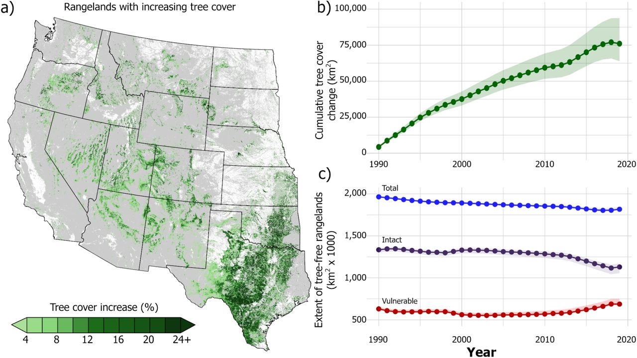
Woody expansion in western rangelands from 1990-2019. Texas and Oklahoma have been particularly hard hit by tree encroachment, though nearly all western rangelands are seeing more trees. Figure 2 from paper.
The second big finding was that since 1990 producers have lost roughly 332 million tons of forage production on U.S. rangelands. This loss is roughly equivalent to the total grass production of North Dakota over the same period. This lost production is valued at $4.1–$5.6 billion after accounting for variability in livestock biomass use and forage value. These kinds of numbers make people stand up and take stock of the need to proactively manage woodland expansion into grasslands.
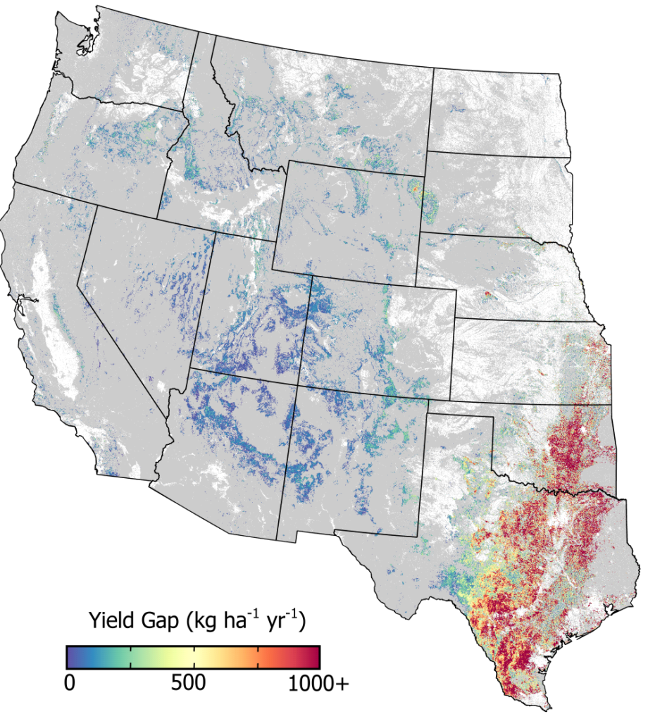
Yield gap in herbaceous production attributable to woodland expansion from 1990-2019. This map depicts the most severe yield gaps (red color), which are found in the southern Great Plains. Production losses extend north and west into sage-steppe rangelands. Cultivated lands and built environments shown in white. Figure 4 from paper.
Lastly, for me, the increase in the rate of tree expansion in the northern Great Plains was alarming. Tree expansion isn’t in the public consciousness up there, but we’re starting to see that real uptick in this threat. Being able to show that in the science and then to communicate it to people is really important. After doing this analysis, I’d remind anyone up north that the best time to kill a dinosaur is when it’s still in the egg.
How does one measure herbaceous production to get at these answers?
In the past, people went out into the grassland with scissors, clipped the grass and flowering plants, put them in a bag, dried them, and weighed them. And then we used those plot-based measures to extrapolate production changes across larger areas.
But with technological advances we don’t have to sample production in one place and hope it applies elsewhere anymore; instead, we can use satellites and have accurate measures everywhere. Technology allows us to look at changes in production every 16 days, or annually, and we can evaluate the impact of changes from images that go back 30 years. When we combine the satellite and meteorological data, we can see how much grass or forb production is happening on a very specific piece of land, or across big landscapes.
There must be many factors that influence herbaceous production, like drought. How did you estimate the amount of lost production that is directly attributable to expanding trees?
We used satellite images and lots of computer power to investigate how production and tree cover change together over time. We have tools that use these satellite images in combination with meteorological data, topography, soils, and on-the-ground vegetation information to learn how production responds to tree cover expansion. These tools also tell us what production should be if trees never moved in since there are plenty of places on the landscape where tree cover remains unchanged through time. This gives us a direct way to estimate lost productivity due to trees by comparing the actual production with what it could have been if tree cover stayed constant over the past 30 years, while still accounting for year-to-year variation in climate.
Put another way, our computer models allow us to turn up or turn down the tree cover, like the volume knob on a radio, and see how production is impacted. Importantly, our analysis does not try to remove trees that are already on the landscape historically. Rather, we simply ask what production would be if tree cover remained unchanged over the past three decades instead of increasing steadily as we’ve observed.
Where is tree expansion happening and how have these big changes gone unnoticed?
Tree expansion is a global phenomenon that is accelerating grassland losses on every continent except Antarctica. Here in the U.S., WLFW is addressing tree expansion in the Great Plains grasslands and farther west in the sagebrush biome. Across this broad geography, expansion generally stretches from the north to south with a few exceptions in California and the desert southwest where tree cover is decreasing in response to prolonged, unprecedented drought.
Our findings show that the rate of tree expansion rivals that of cultivation.
What strikes me is that most people still don’t recognize the loss of grasslands to trees as a major ecosystem threat. Most people easily identify the big impact when a grassland is cultivated, but few notice the impact on biodiversity when an intact grassland converts into a woodland. This is due in part to how slowly trees colonize new areas, but I also think people are programmed to appreciate trees on the landscape, even if they don’t belong there.
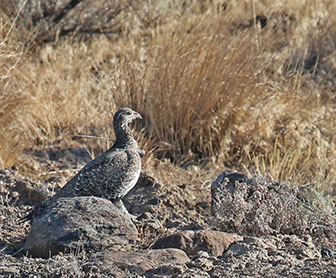
Sage grouse are a specialist species – they need large expanses of tree-free rangelands to survive. Research has shown that sage grouse will abandon otherwise suitable habitat when just one or two trees per acre appear. Photo: Tatiana Gettelman, Yakima Training Center
It’s important to understand that even very small changes in tree cover drive big changes in biodiversity. Grassland specialist birds, for example, will stop using a site when tree cover reaches just a few trees per acre. Most of us would miss that change unless we’re really keyed into a site. From a producer’s perspective, catching tree expansion at these initial stages is when you want to address your tree problem. If you wait until you have 10%, 20%, or 30% tree cover, you’re seeing real impacts on production, and tree removal becomes very expensive.
How do declines in productivity caused by trees compare to those from severe drought?
Every year, trees are reducing the overall production of forage on western rangelands by 5-6%. That may seem like a small number, but at a national scale, and from an agronomic perspective, it is a big deal. If you’re a rancher in southern Oklahoma where tree expansion is severe, you’re probably experiencing production declines of closer to 30-60% a year, every year.
At the national level, a 5-6% loss is equivalent to a sector-wide drop in crop productivity caused by a severe drought. But droughts are relatively infrequent, maybe every eight or 15 years, depending on where you are. The average west-wide decline in productivity caused by woodland expansion is similar to that of a severe drought, but it’s happening every year, year after year, it’s happening across large swaths of western rangelands, and it’s growing.
There’s also a compounding effect. If you’re a producer in the western U.S. dealing with tree expansion and a severe drought happens, the combined impacts on productivity become that much bigger. Even after you recover from the drought, the production loss from tree expansion is still there and getting worse.
Speaking of the data, your paper mentions that the relationship between production losses and expanding trees isn’t linear. Will you explain this finding a bit more?
The easiest way to think production losses it is that these things act like a threshold or like you’re stepping off a cliff. Early on, as trees are expanding, you see relatively little loss of herbaceous production, which can lead people to think there’s not a problem. But eventually that all changes. Trees outcompete the native grasses and forbs for water, sunlight, and nutrients; then herbaceous production drops, and it drops fast.

Eastern redcedar trees have converted this once productive grassland in Nebraska to a woodland. As trees move in and become denser, forage production drops.
So, you may have a situation where for the first five, 10, or even 15 years that trees move into a grassland, there’s not much change in production. But then from years 20 to 25, all of a sudden, over that five-year period, you’ve lost 30-40% of your production. And, from there, the rate of loss keeps going up as time goes on.
Importantly that timing depends on where you are in the country, but there will be a drop off. The point we’re trying to make with the paper is that we can’t afford to wait until that threshold is met. We need to be proactive.
How is this information being used to bolster grassland conservation?
In the Great Plains, where more than 90% of the land is privately owned, it’s critical to work with landowners to conserve intact grasslands that support wildlife and livestock production. Even though there’s more public land in the sagebrush biome, much of the productive rangeland there is privately owned as well. So, across the entire western U.S., conservation on privately owned lands is absolutely critical if we’re going to maintain biodiversity, support rural communities, and keep our working rangelands from collapsing.
When we combine the information and data we produced through this research with other information, it allows us to understand where on the ground we should be putting conservation resources. We can prioritize where to work through the Defend the Core strategy and where we need to work with communities to mitigate the impacts that happen when grasslands transition to woodlands.
That’s exactly what WLFW is doing through its biome-specific Frameworks for Conservation Action.

Click on the image to download a fact sheet about lost production from woody expansion in the Great Plains.
This research is part of a growing body of science that is spurring on-the-ground action like the Great Plains Grassland Initiatives, which are proactive state-led NRCS efforts aimed at stopping woodland expansion from affecting intact grasslands in priority areas of the Great Plains. The Kansas Great Plains Grassland Initiative, for example, allocated almost $4 million for removing eastern redcedar from priority areas for 2021, and Nebraska, Oklahoma and South Dakota are investing millions, too. Since 2010, we’ve removed conifers on more than 650,000 acres of land, and we’ve worked with public land managements agencies on cross-boundary work, expanding that amount even more.
Those investments are great news for grass and shrub land conservation. I’m hopeful this research will lead to even more.
—-
This research was supported by the USDA’s Natural Resources Conservation Service’s (NRCS) Conservation Effects Assessment Project – Wildlife Component, the Arkansas Game and Fish Commission, and the Bureau of Land Management.
—LEARN MORE—
Read the paper: “Herbaceous production lost to tree encroachment in United States rangelands.”
Explore country-level productivity data here.
Learn more about the impacts of woodland expansion into sagebrush rangelands through the Pinyon Juniper Encroachment Education Project.
Access a Decade of Science Support in the Sagebrush Biome report that summarizes Working Lands for Wildlife-supported research across sagebrush country.
Access the Loess Canyons Experimental Landscape Science Report that details how landowners in the Loess Canyons area of Nebraska have worked together to stop grassland loss from trees and to restore productive grazing lands. The report also includes recent Working Lands for Wildlife-supported research from this region.
—
The Sage Grouse Initiative is a partnership-based, science-driven effort that uses voluntary incentives to proactively conserve America’s western rangelands, wildlife, and rural way of life. This initiative is part of Working Lands For Wildlife, which is led by USDA’s Natural Resources Conservation Service.
—
Archives
Categories
- Ask An Expert
- Conifer Removal Studies
- Events & Webinars
- Featured Friends
- Great Basin Fact Sheets
- Job Announcements
- News
- Publication Alert
- Sage Whiz Quizzes
- Science to Solutions
- SGI Featured Ranchers
- Success Stories
- Working Lands Snapshot
 |
RSS |
Tags
Bi-State birds California cheatgrass Colorado conifer removal conservation conservation easement conservation easements field staff grazing management Great Basin habitat habitat restoration Idaho jobs mapping tool mesic habitat Montana Nevada NRCS Oregon partners private land conservation rancher ranching rangeland report research restoration sagebrush sage grouse sage grouse conservation science Utah voluntary conservation water West wet habitat wet meadows wildfire wildlife working lands working lands for wildlife WyomingRecent Posts